Friday, July 30, 2010

Don Derigo Nojada Gomez da Silva Fonseca (1823-1905)

W.G. Fonseca. Credit

Born in St. Croix in the West Indies, Don Derigo Nojada Gomez da Silva Fonseca was reportedly a cousin of a President of Brazil, Deradora d Silva Fonseca. In 1840, he left St. Croix for New York City (then a city of 310,000 souls living below 14th Street) where he received business training as an apprentice, and shortened his name to William Gomez. By 1850, he was doing business in St. Paul, at the time an isolated town in Minnesota Territory experiencing a boom. After nine years there, he traveled to the Red River settlement with a caravan of Red River Carts, arriving in the spring of 1860, crossing the river and landing at what would later be the foot of Lombard street.

Spending his first night in the boat on the western banks of the river, Fonseca went ashore, meeting Andrew McDermot, then the most prosperous free traders at River. Fonseca first rented a log house near Redwood, near the present Redwood Bridge, where he sold the goods he had brought with him from St. Paul. With that money, he purchased the lot in Point Douglas, along a street that Fonseca would lay out and call Maple, after the trees he planted there. The property would be subdivided over the years to make way for new developments, but much of the grounds around the house, known as Maple Place, would remain surrounded by trees and gardens.

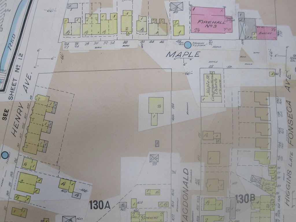
Maple Place and its environs, 1905. The Fonseca residence is seen in the centre

Later that year, Fonseca went into business with another recent arrival from the U.S., Edmund Lorenzo Barber. In 1861 he opened a store with William Logan, which was "situated near the Old Mill" on the Logan estate, not far from Maple Place.

Fonseca Terrace. Built on the south side of the Fonseca estate at 99-111 Henry Avenue circa 1872--perhaps the first "multi-family dwelling" built in the city. Fonseca can be seen standing on the sidewalk in the centre

In 1869, Fonseca was arrested and detained for two days by Riel when shipping goods from St. Paul to Red River, but was released on account of his American citizenship.

In addition to his business ventures, Fonseca was intensely involved in city affairs, serving six terms as Alderman, a school trustee, as well as serving on the Vestry of St. John's Cathedral for 36 years and numerous other committees. By 1871, Fonseca had built a new house for his young family on the east side of Maple Street, and donated the old log house across the road to the newly-created Winnipeg School Division. It was used as the first public school in the West. Fonseca also donated land to the Manitoba College, which opened at the corner of Main and Henry Avenue in 1874.

Invitation to dinner party at Maple Place, August 26, 1904

The funeral for William Fonseca took place at 3:00 in the afternoon of April 25, 1905, proceeding from the family home on Maple, to a service at Christ Church located at Princess and Higgins Avenue, then up to St. John's church yard, where Fonseca was buried in a graveside ceremony conducted by The Archbishop Matheson. The service was well attended, with many of Fonseca's contemporaries in attendance: Lady Schultz, E.L. Drewry, and the Bannatyne's. Sir Daniel MacMillan, Sheriff Inkster, James Ashdown, Edmund Barber, Judge Walker, Dr. O'Donnell, and J.D. Moore were the pallbearers.

By 1911, the Fonseca's had moved from Maple Street. Mrs. Margaret Fonseca lived at 602 Wardlaw with her brother John Logan. A son, Benjamin, lived at the family's Wolseley Hotel, and other siblings lived in different houses on River Avenue. By 1928, the old family home, its maple, plum, and crab apple trees cleared away, and the site became a trucking yard.

Since the area that Fonseca lived and invested in was subject to decades of decline and urban renewal projects, the only remaining legacy of the pioneering Point Douglas entrepreneur is the Mount Royal Hotel at 186 Higgins Avenue, which Fonseca and his sons built in 1904.

The Wolseley Hotel on Higgins Avenue, can be seen on the left. Across the street is the imposing Royal Alexandra Hotel. Credit

Mount Royal Hotel, built by W.G. Fonseca in 1904. Credit

Thursday, July 29, 2010

Lily Street, 1911

Lily Street from Alexander to Henry, as it appeared on the 1905 Winnipeg Fire Insurance Map. Click to enlarge

Lily, the short street in south Point Douglas that extended from Pacific Avenue up to Henry, was laid out early in the 1870s. By 1911, it was entirely residential, made up mostly by detached frame houses, with two apartment blocks at the street's north end. While south Point Douglas in 1911 was one of the city's most densely-populated districts, made up largely of new immigrants, Lily Street was home to a number of the city's Jewish merchant and professional classes: Zimmerman, Ripstein, Rosenblat, Margolese, Moscovitz, Bronfman.

William Zimmerman lived in a modest wood frame house at 23 Lily. Arriving in Winnipeg with his family at the age of 12 in 1882, the Zimmerman's spent their first summer in Winnipeg as most immigrants in those early days did: living in the shantytown that existed where the Canadian Museum for Human Rights is under construction today. Within five years, the family were able to open a general store at 669 Main St. In 1913, William replaced the old store with a three-storey building, which still stands at this location.

Drawing of William Zimmerman's new block at 669 Main, designed by Max Blankstein, 1913. Credit

At 39 Lily, Dr. Oscar Margolese came to Winnipeg from Eastern Canada in 1906, and in 1911 his offices were at his residence. Dr. Margolese specialized in urology, and practiced until at least 1919. He was a founding member of the B’nai B’rith Lodge in 1911.

Joseph Fahey moved to 46 Lily in 1882, and would remain there until 1933. He was a prominent union supporter in the early 20th century, and the Arlington Hotel which he managed was known as "union headquarters" early in the century. (The Arlington was located on Market St. across from City Hall.) Joseph and his wife Ella raised three sons, all of whom served in the First World War. Two of these boys, 29 year-old Ernest, and 22 year-old Jack, were killed in action in 1918.

Daniel McDonald lived in a brick house at 45 Lily. Retired as Western manager of the Confederation Life Co., the 77 year-old McDonald by 1911 would have been a vestige of the Anglo-Celt executive class in Point Douglas.

The house at 51 Lily had been constructed circa 1895 by Alexander Black, whose lumber business was located a few blocks east on Gomez St. By 1911, the house was occupied by Nathan Rosenblat, who operated a hardware and clothing store at 651 Main, in what is now the Man-Win Hotel.

51 Lily circa 1962. Demolished in 1970. Credit

At 60 Lily, which looked down George Avenue to the river, lived Yechiel and Mindel Bronfman, with three of their children: Laura, Allen, and Rosia. Two other sons lived at two Main Street hotels that managed: Harry at the Patricia, and Samuel almost directly across the street at the Bell. In the 1920s, the Bronfman family would move to Montreal, where they built the Seagram's distillery empire.

In 1927, the block between Alexander and Robert (Galt) Avenues was bought up by the T. Eaton Co., including the Zimmerman residence, where they built a large two-storey warehouse that remains there today. William Zimmerman moved to an apartment on Central Park, where he lived until his death in 1946.

William Zimmerman, n.d.

On December 29, 1944, a 77 year-old man was crushed between a truck and the wall of the warehouse at 181 Bannatyne Ave. The driver of the truck was 61 year-old George Bell, an express clerk with the CPR, who lived with his wife Constance at #16-76 Lily, The Exeter Block. Less than a year later, in September, '45, he Tribune reported that the fire was caused by a cigarette being butted out on the couch, and that a drunk George was rescued by the caretaker with some difficulty, believing his wife was still inside. George died from his injuries at the hospital several days later.

South Point Douglas, circa 1910. This view shows Henry Avenue, with Martha St. on the right. The trees and houses of Lily St. can be seen in the background. The rear of the Exeter Block is shown on the left. Credit

In the early 1960s, almost all of Lily between Logan and Henry was demolished to make way for the connecting 'freeway' between the Disraeli Bridge and Main Street, and the new CPR office building on Henry (now the Manitoba Metis Federation headquarters). The new roadway cut diagonally across the Fahey property, and where the Bronfman house stood at 60 Lily became a parking lot for the CPR building.

Daniel McDonald house at 45 Lily, c.2000. Credit

The ornate late-Victorian Alexander Black house, home to Nathan Rosenblat in 1911, was demolished in 1970 in spite of the protest of a handful of architecture students and local history buffs. Fittingly, an auto garage was built there in 1980. Today, only two houses remain on Lily Street: the Daniel McDonald residence, which appears to be well maintained, and a duplex at numbers 55-57, which appears to be one of the last of the South Point Douglas flophouses.

Wednesday, July 28, 2010

137 years at Main and Logan

Since 1873, there has been a hotel operating at the south-east corner of Main and Logan Avenue. First established as the Eureka House, it was later known as the California, the Ottawa, the White Rose, and by 1900, the Occidental Hotel. Rechristened the the New Occidental sometime in the mid-20th century, it is now officially known as the Red Road Lodge.

The Eureka Hotel was built at this corner by Alexander Logan, heir of the Logan family estate that encompassed everything between Henry and Alexander Avenue before the family subdivided and sold off much of it in the 1870s and early '80s. Next door to the Eureka in 1873 was the Point Douglas House, operated by Paul Heiminck, which kept in stock "Guinness' Porter, Bass' Ale, Carte d'or Champagne," as well as liquors, cigars, sardines, lobsters, oysters, pickles, "and everything else necessary for a lunch."

Ad for Eureka House in the Manitoba Free Press, January 17, 1874.

Another ad placed in the Nor'wester (the first newspaper in the West when it began publishing in 1859, it was briefly resurrected in 1874 under the ownership of E.L. Barber, advertised that the Eureka House's proprietor Joseph Devlin had enlarged the building, so that "travellers and the public generally" could be entertained "in first class-style." Board was available by the week, with or without lodging, and the hotel's stables were "large and commodious," Devlin keeping "constantly on hand the best of hay & feed."

In 1882, the hotel operated under the name California, and according to a profile on the city's hotels in the Winnipeg Sun in September '82, the California was a wooden structure with 12 bedrooms, a dining room, and bar.

At some point between the mid 1880s and the early 1890s the hotel was either upgraded or totally rebuilt. It is likely that it was rebuilt, since the Sun claims the building was wooden, while the fire insurance map from 1905 shows the hotel was of brick construction.

West side of Main at Logan Avenue, 1892. Credit

Ad in the Winnipeg Telegram for a Christmas dinner, December 24, 1904. Credit

In the 1890s, the hotel, by then called the White Rose, was purchased by a Jewish merchant named David Ripstein. Born in Russia, Ripstein came to Winnipeg in 1881, and was a wholesale liquor dealer prior to purchasing the White Rose, changing the name to the Occidental Hotel in 1894--the year Alexander Logan, scion of the old Red River family, died. At the turn of the century, Ripstein frequently found himself in court for various (usually liquor-related) offences--a common occurrence for small businessmen in an age of strict liquor sales and Lord's Day laws. He also served as President of Shaary Zedek Synagogue, then located at the corner of King Street and Henry Avenue.

Ad placed in the Nor'wester, August 13, 1895. Credit

In 1903, Ripstein built a three-storey addition at the back of the Occidental on Logan Avenue, and three years later built an adjacent building, called the Ripstein Block, at the corner of Logan and Martha Street. It was here, at #1-48 Martha Street, where Ripstein lived in 1911 with his wife Mary, his mother-in-law Annie Shapra, his two year-old grandson Clarence Ripstein, and a domestic servant named Sophie Magnason.

Drawing of the Ripstein Block, which appeared in the Winnipeg Telegram in April, 1906. Credit

Fire Insurance Map from 1905 showing the Occidental Hotel, with the first of David Ripstein's Logan Avenue additions shown. The small wooden buildings on the opposite side of Logan can be seen in the 1892 photo above. They would be replaced the following year by the five-storey Bon-Accord Block, designed by the architect A.M. Fraser.

The Ripstein Block and Occidental Hotel, seen from Logan Avenue, 1918. Credit

Entrance to the hotel, 1918. Credit

Given its relative old age and outdated floor plan, the Occidental by 1914 would certainly not have had the appeal of larger, newer hostileries on Main such as the Royal Alexandra, the McLaren, and even the Bell, to say nothing of the Marlborough, St. Regis, and other more uptown establishments. It is likely that the Occidental's decline in status began long before 1945, the year that the hotel advertised daily rates of $1.00 (about $13.00 today). But as transportation patterns began moving away from railways and Main Street at a rapid pace after World War II, the Occidental began to assume something of a rough character. When one Main Street old-timer was asked which was the roughest hotel on the strip in the early 1960s, he responded without delay: "the Occidental. Maybe the Brunswick [Main and Rupert], too. But the Occidental was bad."

The "new" Occidental Hotel, circa 1980, a time when it was famously the epicentre of Main Street's roughest and wildest years between 1965 and 1999. Credit

In the early years of this century, the Occidental was purchased by Richard Walls who, much to the chargrin of the socially responsible Manitoba Liquor Control Commission and the community-building Manitoba Lotteries Corp., shut down the bar and removed its VLTs. Today, it operates essentially as a quiet and seemingly well-run hotel for long-term tenants upstairs, with space on the ground floor used by different organizations. The most notable of these is The Tallest Poppy restaurant, a popular eating spot which was opened by Point Douglas entrepreneur Talia Syrie in 2006.

Friday, July 23, 2010

Ratepayers vs. The Company

In 1902, as settlement in Western Canada continued to expand dramatically, traffic on the Canadian Pacific Railway's main line through Point Douglas continued to increase. Since 1881, the CP's railroad had run down Point Douglas Avenue, a public road, but over the years, train traffic increased, more tracks were laid, and numerous spur tracks ran off the main line to connect to the district's various industrial and wholesaling concerns.

As traffic on the mainline grew, so was the city. New residential neighborhoods sprouted further and further from the central core. For citizens who traveled by streetcar, a fare from the North End to downtown involved getting off at one side of the CPR on Main, walking to the other side, and catching another streetcar. That is of course if trains were blocking Main Street.

Canadian Pacific Railway Station, showing Point Douglas Avenue on the right, with Main Street in the background, 1900.

For residents in the north-east section of Point Douglas, the isolation that the busy CPR mainline caused was much worse. Sutherland Avenue extended east only as far as Disraeli Street, and residents east of Disraeli were forced to use Point Douglas Avenue to access points westward, either by walking along it, or crossing it to Higgins Avenue.

"Has the city council given the street over entirely to the CPR?" an "interested ratepayer" wrote to the Winnipeg Telegram.
There was no meaningful way to access the rest of the city without accessing Point Douglas Avenue. Children living north of the tracks, who could not attend the crowded Norquay School on Euclid, would daily cross the mainline at McFarlane to attend Argyle School. The at-grade crossing at McFarlane Street had five tracks to cross, and "almost constantly there are cars standing on the Ogilvie [Flour Mill] switches," making it extremely dangerous to cross, particularly for young children, who "are apt to be heedless." People living here, the writer concluded, "are practically cut off from the protection and privileges enjoyed by the rest of the city."

In April, The Voice reported that John Wallace addressed a meeting of the Labor Party regarding the "heap of trouble that is stewing at a very persistent rate in the hearts of Point Douglas residents." Wallace called for Sutherland to be extended from Main Street to the Louise Bridge, and at no increased property tax rates for nearby residents, since their "only outlet," Point Douglas Avenue, had become gradually overtaken by the CPR without any compensation.

Point Douglas circa 1900 showing Sutherland Avenue ending at Disraeli St. Credit

In 1903, the C.P.R. began to construct a subway at Main Street under Point Douglas Avenue, which was opened to the public by November of 1904. The Company also promised to construct another further east.

Earlier that year, E.F. Hutchings, the wealthy saddle merchant and financier late of 47 Martha Street, came before Council on behalf of the Winnipeg and St. Andrew's Railway company, with a plan to build a railway line between Tyndall and Winnipeg, with the intention of delivering stone and sand to the booming city. Hutchings asked the City grant use of the Louise Bridge, recently vacated by the CPR, for the W&SAR. The line would come down either Point Douglas or Sutherland Avenue, terminating near Main Street.

Alderman Wood remarked that if the railroad brings more sand into the city, Council should support it, as he felt "many of them needed a little more sand." To this, the reporter went on, Alderman James G. Harvey "puffed vigorously at his pipe, the engineer suppressed a smile and City Clerk Brown meditatively stroked his whiskers." I guess you had to be there.

Story in the Telegram on a new railway plan for Point Douglas, June 1, 1904. Credit

Council informed Mr. Hutchings that they could not say for certain if a new track on Point Douglas Avenue, but did not see any objection to the W&SA using Sutherland.

Hutching's rail line was not constructed through Point Douglas. Sutherland Avenue was extended to the Louise Bridge by 1906, and both were not used for railways. While Point Douglas Avenue was given over almost exclusively to the CPR, the Company would build three more underpasses (at Higgins, Annabella, and Maple) in Point Douglas by the close of the decade.

At the time it could have been reasonably assumed that the residential enclave north of the mainline and east of Euclid would disappear, given over entirely to industry. These assumptions would be proven false, as a substantial enclave of residences still exist on streets like Stephen, Syndicate, and McFarlane. In the end, nothing--not railways or freeways, boom times or depressions; not too little planning at the turn of the 20th century, or too much planning in its second half--could make these ratepayers disappear entirely.

Thursday, July 22, 2010

Klyne's Mill

Edmund Lorenzo Barber, the hapless American entrepreneur who came to Red River in 1860, whose famous house stands forlorn at 99 Euclid Avenue, a Phoenix not yet taken flight, was not the first person to occupy the site. The history of the property where the neighborhood's oldest house now stands actually goes back further than the 1860s.

The Barber House seen from the back, 1959. Credit

Barber first went into business in 1860 with another young man originally from the West Indies, who arrived at Red River the year before: Don Derigo Nojada Gomez da Silva Fonseca, who would be known more simply as William G. Fonseca. These two men would become leading citizens of Point Douglas, and by virtue of their devotion to investing in Point Douglas, or perhaps their unsophistication to changing business practices, or simply bad luck, they would both live out their days in the neighborhood, long after their contemporaries had exited for Wellington Crescent and Armstrong's Point: Barber at his house on Euclid, Fonseca on Maple Street in South Point Douglas.

Barber and Fonseca's store was located at Redwood, the residence of William Inkster, and opposite Inkster's steam mill. Built in 1857, Redwood later became the site of the Drewry Brewery, and of course the avenue and bridge that bears its ancient place name.

The next year, Barber opened his own store "at Mrs. Campbell's, near Fort Garry." The exact location of this store is unclear, but the scope of its merchandise was quite vast. In an ad placed in The Nor'wester, Barber notes he carried "Dennims, Jeans, Plaids, Under Shirts, Hoop-Skirts," as well as "Tea, Dried Apples, Powder and Shot, Scythes, Children's Toy Books, Slates and Pencils, Perfumery, Hair Oil," among many other things.

In late 1862, Barber moved once again, this time, his ads proclaimed, to "near Klyne's Mill, on Point Douglas."

This map places Michel Klyne's Mill near the site of Barber House in North Point Douglas. Credit

Michel Klyne, a Catholic Metis, had operated a mill at mid-century in the vicinity of the present Barber House. The Klynes had lived on Point Douglas at least as early as 1832. It was Klyne's thatch-roofed residence, Thistle Cottage, that Barber moved to, and that his present house either replaced or added to.


Owing to the tough economic times the early '60s were for Red River, Barber wasn't picky: "In payment he will take Wheat, Barley and Flour, as well as Money," an ad in November read. He also took, it would seem, IOU's; in April of '63, Barber asked that "[a]ll persons owing me wheat or flour would confer a favor by paying me at once, or as soon as possible."

Ad placed in the April 13, 1863 edition of The Nor'wester. Credit

Barber would operate his store from the Euclid Avenue property until the winter of 1870-'71, when he relocated to "the High Road at the corner of Logan's Farm and Point Douglas." Or, as Winnipeggers of today would know it, the corner of Main Street and Henry Avenue. He continued to live at 99 Euclid until his death in 1909.

Wednesday, July 21, 2010

Tory Row

Winnipeg's North End is famously known as the fountainhead of Western Canadian social democracy that, by the second half of the 20th century had become a national force. It is interesting, then, that for a brief moment in the 1880s, soon after Point Douglas had become established as a neighborhood defined by industry, railways, and Eastern European immigration, that a short stretch of Hallet Street would be home to three dominant Manitoba Conservatives.

Colin H. Campbell (1859-1914) was Manitoba's Attorney-General from 1900-'11, Premier John Norquay (1841-1889) was Premier of Manitoba from 1878-'86, and Nathaniel Boyd (1853-1941) became a young star of Robert Borden's federal Conservatives, and was an M.P. from 1891-1904.

Winnipeg Fire Insurance Map showing part of Hallet Street in 1905

Colin and his wife Minnie were newlywed twentysomethings--he a lawyer and she active in many social and church-related causes--who lived at 79 Hallet, a brick duplex. The Hon. and Mrs. Norquay lived in a large duplex two doors down, at 73. Their neighbors, the lumber merchant Nathaniel and his wife Eliza Boyd, were at 71, in a frame house Boyd constructed in 1882. Letters between Colin and Minnie Campbell from the summer of 1886 speak of evening visits among these families, as well as others including Boyd's partner in the lumber business, George Crowe and his wife who lived at number 67.

By 1890, these three men were gone from Hallet Street. In 1888, the Campbells moved to 149 James Ave. (and eventually to Roslyn Road), while Nathaniel Boyd moved to Carberry, MB to raise cattle. In July of '89, John Norquay died at the Hallet St. residence. His wife and children remained at that address for several more years.

Residence of John Norquay, c.1938. The Norquays occupied the right half of this building

In 1941, the Norquay residence was demolished, with part of its foundation and bricks used to construct two smaller houses on the site. The Campbell and Boyd residences are both standing today. Boyd's house was occupied by a series of long-term residents; while the Campbell duplex served as a boarding house through most of the 20th century, until 2005, when it was extensively renovated as four separate apartment units and occupied by new Ukrainian and Russian immigrants. It reportedly sold this month for $200,000.

Roseville Cottage

In the summer of 1875, the merchant John Higgins constructed a house along the river at Point Douglas, known as Roseville Cottage.

At 68, John Higgins was one of the oldest free traders at Red River, first peddling general goods by cart around the settlement. By the time of the Provisional government in the winter of 1869-'70, Higgins had partnered with W.H. Lyon in a store built on the west side of the main road opposite Post Office Street. In 1874, Higgins built a new brick store on the same site, described as "a mammoth mercantile palace" that the Manitoba Free Press speculated would be "extremely doubtful if it is excelled by many metropolitan shops. It certainly stands out from the smaller wood frame commercial buildings that lined the main street of a brand new and desperately optimistic city.


The new Higgins store (left), on the west side of Main St. just south of McDermot, c.1875. Credit

Roseville Cottage stood on five acres of land on the south riverbank in Point Douglas, near the foot of present-day Gomez Street. In an article in the Manitoba Free Press, it was noted that Higgins' new house was a 15-minute walk to the post office (then on present-day Lombard Avenue), and commands a “good view of the river and a large portion of the city.” The grounds around the house were neatly landscaped with grass, and ornamental and fruit trees. At the back of the lot, extending up to Point Douglas Avenue (present-day CPR mainline), Higgins used the land for market farming.

The house itself was constructed of brick and featuring two bay windows, a small portico at the entrance, and three arched dormer windows protruding from the hipped roof. At a time (not unlike today) when every new impressive building offering validation to the local civic esteem, boosters could get a fix by strolling past Higgins' new residence; the Free Press noting that "those who are anxious to see what our Province can produce will be able to form a high opinion of Manitoba by a visit to Roseville Cottage."


Roseville Cottage, c.1880. Credit

John Higgins remained at the house until his death in 1884, and it appeared on the 1905 Winnipeg Fire Insurance Map, surrounded by the Alexander Black Lumber yards. It is likely that Roseville Cottage was demolished early in the 20th century.